The IRIS airborne integrated LiDAR hyperspectral imaging system is a higher order airborne hyperspectral remote sensing solution independently developed by IRIS. By integrating real hyperspectral data and higher quality orthorectified data, and utilizing a joint analysis platform for terrain stereo morphology information and spectral information, we provide users with higher quality spectral remote sensing data.
With the help of an external push scan imaging spectrometer, it is possible to obtain true hyperspectral data (rather than frame based band splicing spectra) with incomparable spectral sampling intervals and true spectral resolution, which is the foundation for accurate remote sensing applications.
With the help of line scanning LiDAR, surface elevation can be obtained, which enables extremely accurate orthorectified calibration of images. At the same time, the three-dimensional shape information of ground objects can also be obtained, and combined with spectral information analysis, opening up a new research perspective.
Compared to using separate LiDAR and hyperspectral imagers separately for data synthesis, the IRIS all-in-one machine has significant advantages.

The two sensors in the all-in-one machine are in a rigid system, and after calibration, there is no error in coordinate conversion during the use of DEM;
The IRIS laser radar system provides higher elevation accuracy, with a horizontal accuracy of ± 2cm and an elevation of ± 1cm;
Besides DEM, elevation and shape data can be analyzed together with hyperspectral data to achieve more functions;
√ Lower procurement and operating costs (fewer flights) and higher measurement efficiency.
Application Cases
Location 1: Zhuozhou Agricultural University Science and Technology Park, China Agricultural University
Instrument model: IRIS airborne integrated laser radar hyperspectral imaging instrument


Location 2: Northeast Normal University
Instrument model: LR1601-IRIS airborne LiDAR systemMS600 multispectral imaging instrument, PSDK101S oblique photography
Measurement sensors and ZENMUSE X7 orthographic aerial survey sensors


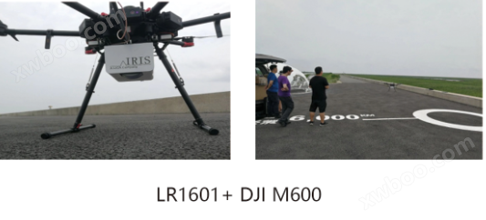
Location 3: Fudan University Chongming Island Field Test Site
Instrument model: LR1601 airborne LiDAR system, equipped on DJI M600 multi rotor unmanned aerial vehicle platform


Main technical indicators
Scanning frequency: 320000 points per second
Number of scanning lines: 16, 32 lines optional
● Measurement range: 150 meters
Horizontal accuracy: ± 2cm (1 σ)
Elevation accuracy: ± 1cm (1 σ)
Pitch and roll (RMS): 0.04 ° (PPK)
Spectral range: 400-1000 nm
Spectral resolution: 2.1nm
Sampling interval: 1.07nm
Number of spectral channels: 561
Number of Bin spectral channels: 281
Number of spatial channels: 900
● Frame rate per second: 249
● Average RMS radius: 6 μ m
Hyperspectral imaging equipment and LiDAR equipmentShared IMU/GPS software and hardware seamless compatibility highSpectral airborne system, jointly carrying unmanned aerial vehiclesSynchronize data acquisition, software can achieve highlightsSpectral and laser point cloud, RGB multi-source datafuse
● Supports multiple GNSS systems: Beidou, GPS,
Glonass and RTK technology
● Integrated machine weight: 3.2kg

